The 19th century was a period of dramatic expansion in the United States. Now open at the Leventhal Map and Education Center at the Central Library in Copley Square, America Transformed: Mapping the 19th Century shows this expansion through a series of maps. Part One: The U.S. Expands Westward, is up from now until November 2019. The Opening Day Celebration is coming up on Saturday, May 18 from 1 p.m. to 4 p.m., and you're invited!
This event is open to all ages. It will feature a ribbon-cutting ceremony and a talk by Curator Ron Grim. There will also be tours, children's activities, and the debut of an installation by artist Beau Kenyon. Let us know if you have any comments or feedback on the exhibit!
America Transformed uses historical maps, images, and related objects to tell the story of a changing landscape. The exhibit looks beyond myths of the frontier and explores the complex factors that shaped our country. In this post, we'll take a look at some maps from the exhibit and the major themes.

In the United States, we often teach a tidy story of progress and westward expansion. Many historical American maps promote this version of history. Land is one of the overarching themes of our exhibit. Marking the state and county boundaries etched U.S. colonial ideas into the landscape. At the same time, maps often erased Native people from the land. This implied a bounty of untouched and open acreage, ready for Euro-American settlers.
This map (see larger version here, opens a new window) shows that by 1831, the American government had divided the land east of the Mississippi into 24 states and the Michigan territory. American settlement had also expanded west of the river to Louisiana, Arkansas, and Missouri. A year earlier, the federal government enacted the Indian Removal Act. This forced many tribes from their ancestral homelands in these new states. Groups including the Tsalagi (Cherokee), Muskogee (Creek), Chikasha (Chickasaw) and Chahta (Choctaw) endured a march called the Trail of Tears to what is now Oklahoma. The mapmakers printed the names of these nations on the lands left open by their removal.
American expansion owes its success to more than treaties and official wars. The reality is a harsher image: the dispossession and deaths of millions of Native people. This representation is almost completely absent in maps of the time. The Leventhal Map and Education Center worked together with the Akomawt Educational Initiative, opens a new window to provide a Native perspective to this exhibit. Akomawt reminds us that "The perspective of Native populations in the 19th century cannot be properly told in maps, because Native concepts about land are not two-dimensional, and qualifying ownership with a paper document was an imported European concept."
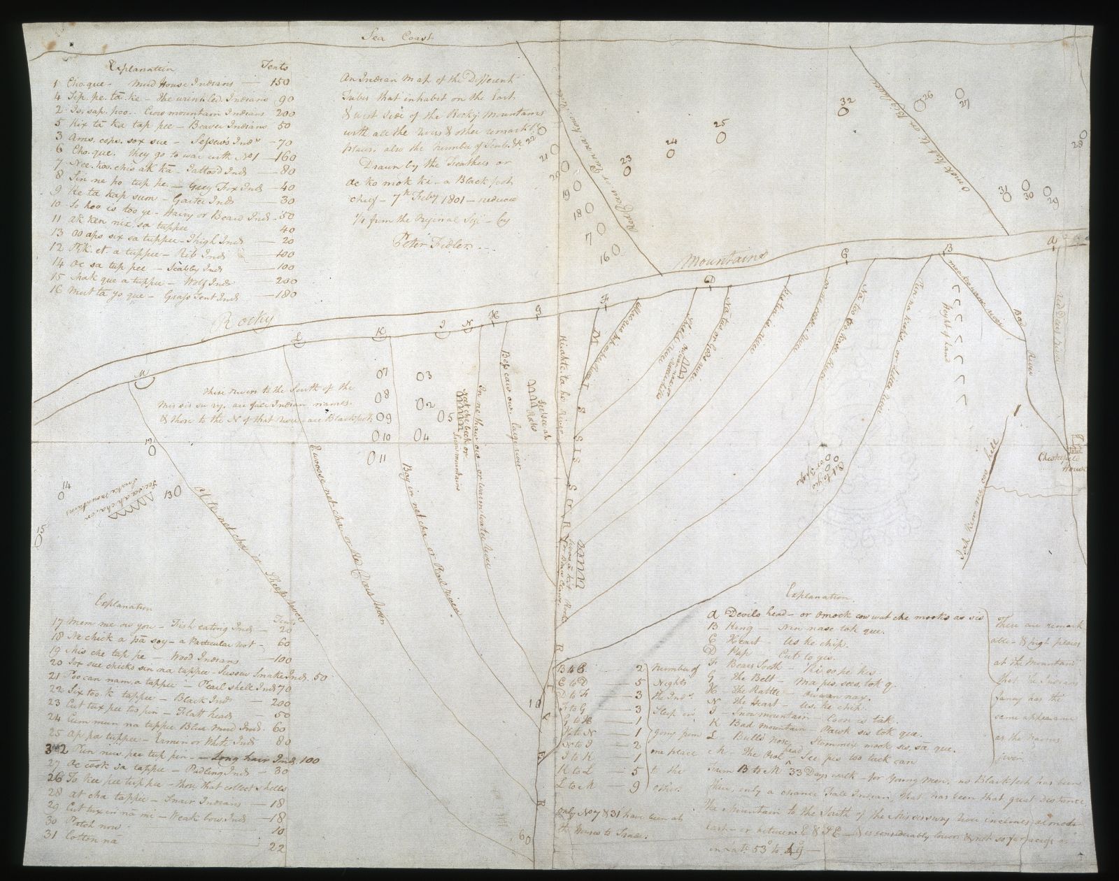
One of the few exceptions to the white perspective in our exhibit is this map of the Great Plains (view larger image here) copied from one by Ac ko mok ki, a Blackfoot chief. West is at the top of the map, and a double line represents the Rocky Mountains. In contrast to the map above, the mapmaker noted over 30 tribal nations. This map was actually sent to London and the geography of the river system was copied into a printed map. The data about tribal nations was purposefully omitted, though, to suggest that no one lived in the region.
This video captures one more highlight from this show. Each mechanized piece represents a major land acquisition, like the Louisiana Purchase. As the pieces move, they cover up Native names and geographies and replace them with state borders and European names. The ease with which the pieces move depicts how people saw and still see the dispossession of Native land as inevitable.
The Central Library of the BPL itself stands on land that was once a water-based ecosystem. It provided for the Massachusett people and their predecessors who lived in what is now the Greater Boston area. We at the Leventhal Map Center acknowledge these indigenous people, the devastating effects of settler colonialism on their communities, and their contemporary presence.

Add a comment to: America Transformed: Opening Day!